(Earth-system Observing Network – Réseau d’Observation du Système terrestrE)
About EON-ROSE
EON-ROSE seeks to be a combined effort of Canadian universities; federal, provincial and territorial government agencies; industry; and international collaborators.
Its overarching vision is to deploy a network of telemetered observatories to monitor solid-Earth, environmental and atmospheric processes.
The Canadian Cordillera Array (CCArray) is the initial phase of EON-ROSE, extending across the Cordillera from the Beaufort Sea to the U.S. border.
A key element of the proposed EON-ROSE and CCArray initiatives involves integrating oceanography, atmospheric sciences, space physics, critical zone (extending from the vegetation canopy through the land surface to the underlying aquifer) science with the solid Earth geosciences.
Vision
The vision for EON-ROSE is to install a network of ~1400 telemetered observatories across the Canadian land mass to monitor the solid Earth, and it’s environmental and atmospheric processes to provide real-time, openly available data.
This pan-Canadian research collaboration, which aims to holistically examine Earth systems from the magnetosphere (the region of space that contains the earth’s magnetic field) deep into the mantle (the layer between the earth’s crust and its liquid molten core), is currently seeking additional collaborators. Groups with a focus on applications of EON-ROSE to space physics, oceanographic, atmospheric, hydrological, cryospheric and ecosystem sciences and numerical modeling including weather, Earth system, land-surface and watershed, are particularly welcome. The ultimate goal is to provide national real-time monitoring capabilities that can support improved tools for risk management, climate change adaptation strategies, ecosystem monitoring, earthquake and other disaster warning systems, and much more.
First Symposium
At the first Symposium on EON-ROSE, which was held in Ottawa, February 21-23, 2018, the focus was on national applications related to:
- Solid Earth and Resources
- Fluid Earth, Critical Zone and Environmental Monitoring
- Natural Hazards and Information Synthesis.
This symposium started with a presentation by Daniel Lebel, the Director General of the Geological Survey of Canada, and an overview of the US EarthScope program by Jeff Freymueller, the Director of the EarthScope National Office in Fairbanks, Alaska.
EarthScope deployed a coordinated west-to-east array of seismometers, geodetic, and other geophysical instruments across the continental US and into Alaska, enabling a wide range of work across the seismological and other geophysical sciences including imaging of discontinuities deep into the Earth’s mantle. The scale (and scope!) of EarthScope attracted broad attention, for example being identified as the top science experiment of the decade by Popular Science in January 2011.
Canadian Cordillera Array (CCArray)
The CCArray is the pilot phase for EON-ROSE.
The Canadian Cordilleran Array (CCArray) is a novel research and observational network constructed to improve our understanding of Earth systems with an integrated approach across multiple disciplines from the magnetosphere through the Earth’s crust into the core.
The research platform is the Canadian Cordillera – the mountainous regions of western Canada – and represents an exceptional natural laboratory to explore interconnected Earth systems that are critical to our understanding of scientific grand challenges related to global change. The Canadian Cordillera Array (CCArray) is a proposed international scientific initiative, spearheaded by creation of a tectonic plate-boundary scale, open-data observational network, that will enable trans-disciplinary research focused on Earth systems processes and boundaries from the core to the magnetosphere.
Building upon the scientific momentum of previous Earth systems research and data collection initiatives including Lithoprobe (1984 – 2004) and EarthScope (2004 ~ 2019), a foundational element for CCArray will be the installation of a network of real-time telemetered observatories. The core of the observational network will be broadband seismometers and Global Navigation Satellite System (GNSS) equipment; additional instrumentation and measurements at selected locations including meteorological and atmospheric gas sensors, borehole temperature and moisture sensors, riometers and magnetometers, and relative and absolute gravimeters.
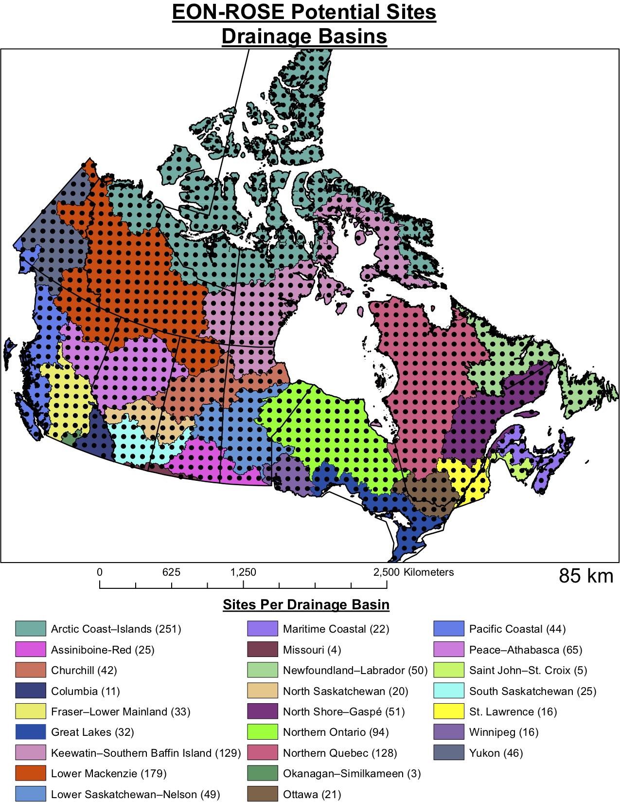
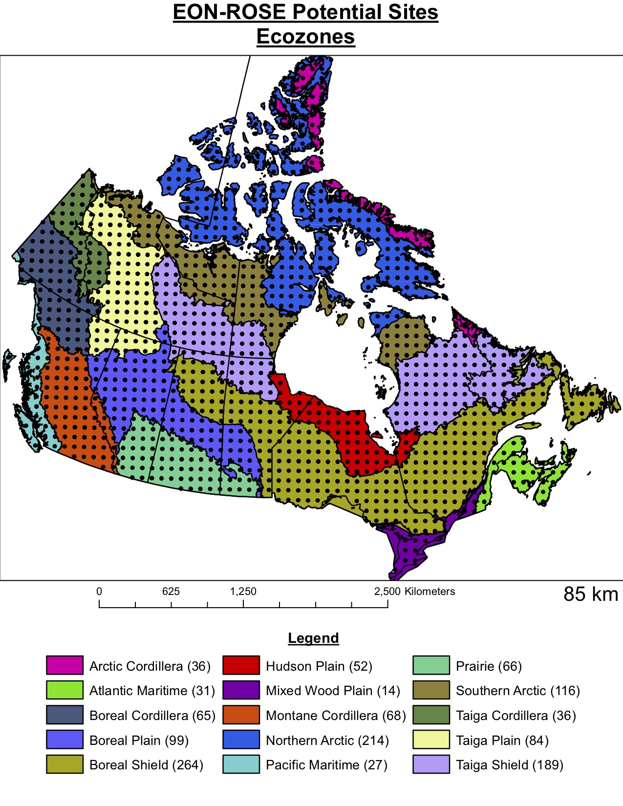
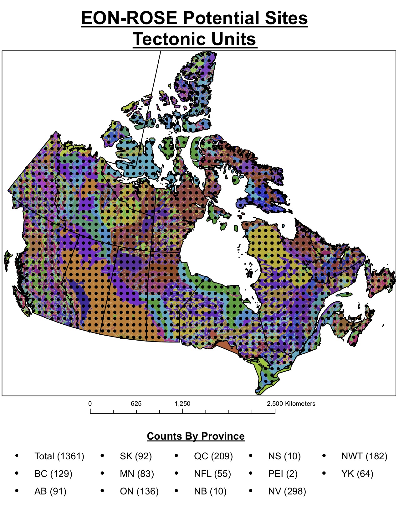
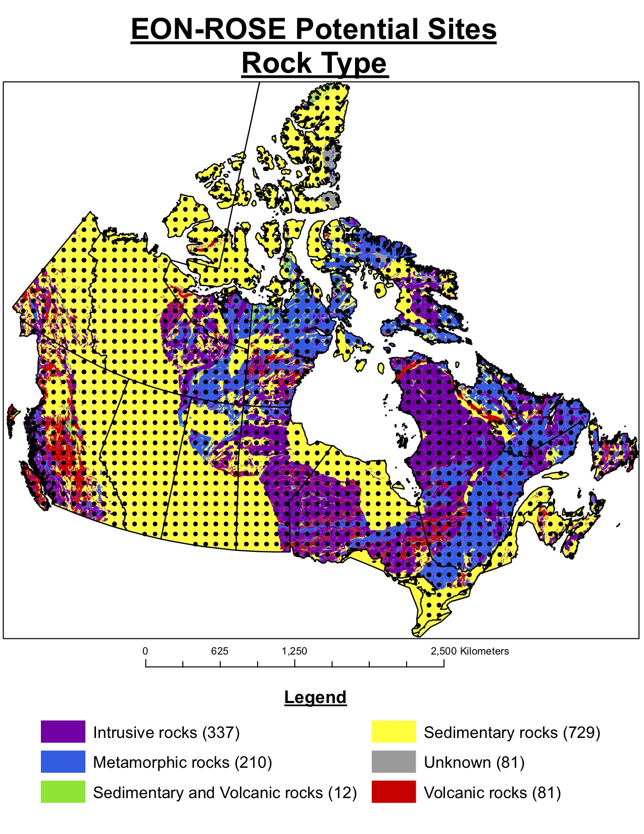
Research objectives include improving our understanding of Earth structure, tectonics, earthquake occurrence and seismic hazard, glacial isostatic adjustment, induced and triggered seismicity from resource extraction, mountain glacier change, and better determining vertical land motion for robust relative sea-level projections. Associated research includes establishment of Critical Zone Observatories, ionospheric and tropospheric investigations, and studies of the active zone and permafrost dynamics. Education-outreach-communication programs will form an integral part of the CCArray initiative. The vision is for CCArray to serve as a springboard for an even more ambitious national initiative in Canada, EON-ROSE. Below are the 1,400 locations proposed for EON-ROSE Earth-System-Observatories across Canada.
The network is a connected series of stations with multiple sensors – seismometers (rapid earth motions), GNSS (slow earth motions), riometers (monitor auroras), magnetometers, gravimeters, weather stations and a variety of other sensors. These stations will be transmitting data, real time, so that everyone will be able to monitor what each station is experiencing and recording.
With Earth’s increasing population, urbanization and waste placing severe stresses on natural resources, as well as increasing our vulnerability to both natural and anthropogenic (human-caused) geohazards, transformative research, such as EON-ROSE and CCArray, is urgently needed to address challenges for environmental stewardship and responsible development of energy, mineral and water resources, particularly within earthquake-prone regions such as western Canada.
Scientific Themes
EON-ROSE and CCArray have a wide range of scientific themes for conducting research. We hope to facilitate new and unique research with the data our seismic network provides.
Expand the themes below to find out more.
Climate-Related Hazards
Along its coasts, Canada is facing a wide range of hazards, including flooding by storm surges and tsunami, coastal erosion and subsidence. In the Arctic, there are additional concerns over loss of glacier and sea ice and permafrost. This research theme will advance monitoring of temporal changes in land, water and ice masses, as well as the hazards resulting from such changes, by integrating data from multiple satellite missions with CCArray observations using Global Navigation Satellite System (GNSS) receivers and devices for precise measurement of Earth’s gravitational field.
Critical Zone
The critical zone extends from the top of the tree canopy to the deepest penetration of groundwater, and is where life interacts with the lithosphere, hydrosphere, and atmosphere. The critical zone provides a link between deep earth and atmospheric boundary layer processes, and acts as the interface through which these disparate zones interact. Thus, critical zone structure and function evolve with changing climatic and tectonic conditions, which regulate water and nutrient availability. From the rapidly uplifting ranges of Cascadia and Yakutat to the rapidly changing arctic landscapes of Tuktoyaktuk, the climatic and tectonic gradients encompassed by the Canadian Cordillera provide a natural laboratory to test how perturbations in climate and tectonic activity affect critical zone evolution. The CCArray “Critical Zone” theme researchers will use a transdisciplinary approach to exploit the dynamic tectonic and climatic environments of the Canadian Cordillera to elucidate critical zone processes and responses. Measurements of shallow hydrological, geochemical, geophysical, and biological characteristics of the critical zone will serve to connect our understanding of how deep earth and atmospheric processes influence life’s progress on Earth.
Geochemistry
Global geochemical cycles maintain the Earth in a more-or-less steady state. Fluid-rock interaction is a major process, which helps sustain these geochemical cycles. Fluids move through the crust along faults and fractures, and are responsible for mass transport of elements and nutrients from the deep crust to near-surface environments. Thermal (e.g., magmatic) and tectonic events are two key drivers for fluid movement. Some of these fluids are responsible for the formation of important exploitable energy-related geological resources, including fossil fuels, geothermal, fissionable materials and metals.
During fluid-rock interaction, minerals can form that are diagnostic of the fluids. For example, chemical and isotopic analysis of these minerals can provide valuable information regarding the timing of when the fluid passed along a fault or fracture and the type of fluid (magmatic, rainwater, brine etc.). These signatures of fluid-rock interactions can affect 1000s of km3 of rock (e.g., sedimentary basins, metamorphic haloes around igneous intrusions) and are often used to explore for natural resources. The Geochemistry theme within CCArray will study the role of faults as conduits for magmatic and hydrothermal activity in western Canada using novel geochemical and geochronological techniques.
Geohazards
The CCArray theme “Geohazards Related to Resource Development and Infrastructure” is broadly defined to cover studies focusing on geohazards that are either resulted from or may have significant impact on the safety and/or operation of the development of natural resources as well as associated facilities and infrastructure. Specific topics include, but not limit to, quantitative characterization of various types of geohazards in western Canada where developments of natural resource are on-going or planned in the near future, delineation of the sources of various geohazards that may have a significant impact on the developmental process of natural resources and the construction of facilities and infrastructure in the context of regional tectonics, and the investigation and simulation of possible interactions between the formation and evolution of geohazards and man-made activities. Two of the most noticeable geohazards related to resource development and infrastructure are induced earthquakes and triggered landslides. A multi-disciplinary approach is proposed to best address these challenging issues with observations from both seismology and space-based geodesy. Targeted case studies will be conducted for significant events with important implications for regional hazard assessment and/or regulatory considerations.
Geothermal Energy
Concerns over climate change are largely tied to combustion of fossil fuels to meet energy demands of society. A transition to renewable non-CO2 emitting energy sources is thus critical to ensure climate stability. Compared to any other renewable, geothermal energy is by far the most reliable source of electricity. Geothermal systems can also provide excellent sources of thermal energy for communities and industry. Indicators for enormous geothermal potential exist throughout the Canadian Cordillera, including numerous thermal springs and volcanoes, yet Canada has not harnessed this energy resource. Exploration and development is hindered by lack of solid geoscience data that can help reduce the exploration risk associated with targeting deep geothermal resources. The CCArray “Geothermal Energy” theme will develop new geoscience tools to support the exploration and sustainable development of geothermal resources. Application of new geophysical methods combined with structural geology, fluid geochemistry, and rock physical properties will be used to help define the occurrence of deep seated geothermal resources that can provide a clean and reliable source of renewable energy to the nation.
Induced Seismicity
The Cordilleran foreland region has experienced a sharp increase in induced seismicity that has, in some cases, been linked to fault activation by hydraulic fracturing. Key to improved understanding of natural and induced seismicity and the hazards posed to people, the environment and infrastructure are detailed pictures of the relationship between seismicity and its causes – be they natural or induced and a better understanding of ground motion. CCArray research will examine the relationship of seismicity patterns to tectonic features and industrial activity associated with development of low-permeability oil and gas resources, including hydraulic fracturing and wastewater disposal. The objective is to characterize both natural and induced-seismicity hazards and the factors that control these processes.
Mineral Deposits
Most metallic mineral deposits form at places where there is a specific geological architecture, and a special set of geological interactions between fluids, magmas, faults and rocks. Because we all consume metals all the time, society demands that we explore to find more. Discovering new mineral resources is increasingly difficult. Much of the land surface has been well-explored, is covered with glacial till, or is off limits to mining activites. Therefore, mineral exploration must increasingly consider the type of geological architecture and locations of past geological interactions deeper and deeper in the crust.
Various geophysical methods, likes the ones included in CCarray, provide researchers with an unparalleled opportunity to ‘see’ into the crust to identify those geological features like deep faults that may be responsible for bringing metal-bearing magmas and fluids to the near-surface. We can look backwards by evaluating features beneath existing mineral deposits, and look forward by considering locations where as yet undiscovered resources may occur.
Tectonic Processes
The Canadian Cordillera and the adjacent continental craton have been built and modified by multiple tectonic events over the last 2+ billion years, including episodes of plate rifting, subduction, terrane accretion, and mountain-building. The CCArray Tectonic Processes Theme seeks to understand the evolution and current tectonics of western Canada, from the Earth’s surface to the upper mantle. What processes have governed the development of the Cordillera? How are these preserved in the modern structure of the continent and underlying mantle? What is the relationship between present-day plate boundaries and deformation/seismicity of western Canada? How do preexisting structures in the continental lithosphere control its evolution? These questions require an integrated approach that combines high-resolution geophysical imaging of the crust and mantle (primarily seismology and magnetotellurics), geodetic and geological observations of current and past lithosphere deformation, reconstructions of tectonic plate boundaries through time, and geodynamic studies of continental lithosphere and plate margin processes. Collectively, these methods span a range of time and space scales to provide insight into the complex tectonics that have shaped this dynamic region.
Water Resources & Cryosphere
Climate change, hydropower generation, flood hazards and control, water supplies, and aquatic ecosystems collectively drive the need to quantify the fraction of runoff from glaciers and snow. Increased emissions of greenhouse gasses will accelerate warming in the decades ahead leading to strong mass loss and subsequent retreat of alpine glaciers. For many catchments glaciers provide cool, plentiful water to streams especially during summer and early autumn when seasonal snow packs have been depleted. Surface runoff from melting snow and ice also provides over 90% of British Columbia’s current electricity needs. Finally, rapid changes in snow cover also poses substantial risk to humans and property. The rain-on-snow floods that impacted Calgary and neighboring communities was the second most costly (over 1.7 Billion in insured losses) natural disaster to impact Canada. Collectively, these examples highlight the important links between the cryosphere and climate and why snow and ice are of great importance to Canada.
EON-ROSE Community Science Liaison submission to The Earth Scientist Journal
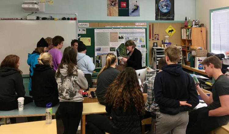
The first EON-ROSE observatories were installed in the Yukon Territory and northeastern British Columbia during the summer of 2018. Those initial sensors were followed by the installation of multiple sensors in the “nested” array Mt Meager program, 150km north of Vancouver, British Columbia, that started deployment during the summer of 2019.
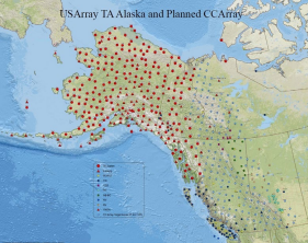
Distribution of ~200 stations (pale blue dots) for the Canadian Cordillera Array at a spacing of ~85km (courtesy of Bob Busby and Susan Azeveda at IRIS). The darker (red) symbols here are the current EarthScope stations in Alaska and NW Canada. There will be what EON-ROSE calls a “nested array” (or densified array) deployed at Mt. Meager (box 100km north of Vancouver) to image what may be magma filling the underlying magma chamber (potentially a significant natural hazard concern).
Below you can see the distribution of 1,400 EON-ROSE Earth-System-Observatories across the Canadian land mass at a spacing of ~85km (courtesy of Thomas James). The network of ~1400 telemetered observatories includes sensors similar to ones that were installed in the CCArray.