- Part 1: Intro / background research
- Part 2: What is Permafrost?
- Part 3: The outing / field trip
- Part 4: Back in class
- How can the Community Science Liaison program help?
Part 1: Intro / background research
- Verbally answer/ discuss
- Where are we?
- What landmarks are around?
- What are their names (are these Indigenous/ English/ other?) and what could this mean?
- Do you know of any other types of landscapes – what are they? Can they all be found in Canada?
- Using maps. Group work
- Locate where you are
- What is around? Can you find any of the landmarks mentioned? Do you know how they formed?
- Compare and contrast different maps and different geographic regions of Canada. Discuss findings.
- Geological map – what rocks can we expect to find. How can we recognise them
- Download geological map of Canada here: https://ostrnrcan-dostrncan.canada.ca/entities/publication/6112b589-8da4-44ca-8f90-c7804d041003
- Go to NWT Geological Maps: https://ntgs-open-data-ntgs.hub.arcgis.com/
- Use NWT mineral kit to see if can recognise any of these when in the field: https://sites.google.com/nwtresearch.com/nwtstemkits-ca/beaufort-delta/mineral-mystery?authuser=0
- Make identification posters for rock types/ landforms for when in the field
- Explore with NWT kit floor map: https://sites.google.com/nwtresearch.com/nwtstemkits-ca/beaufort-delta/giant-floor-map?authuser=0
- What plants can we expect to find? Use NWT kit: https://sites.google.com/nwtresearch.com/nwtstemkits-ca/beaufort-delta/gwichin-plant-kit?authuser=0
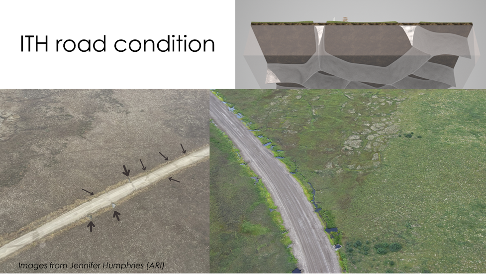
- History of Dempster Highway – when was it built? How was it built? Look at the road condition using pictures in this guide, Google Earth and other aerial images.
- What is it? Definitions from resources (StoryMap, field guide) and online
- Is this unique to this area? Why/ why not? Where else can you find it?
- Which features are regularly found in these types of areas? Can you recognise any of these from the landmarks around you?
- Mix and match – word, definition and picture (matched in correct order below)
Note – the permafrost zones do not have pictures
Definitions and pictures taken from Permafrost Surface Features and Frozen Ground Cartoons unless specified
- Mix and match – word, definition and picture (matched in correct order below)
- Group project: try making a model as to how pingos form and collapse (like making a volcano idea) OR grow your own pingo (here’s how)
- Living with permafrost – using Inuvik as a case study: Dempster Highway, Inuvik Hospital, Lady of Victoria Church, the pipes in town. What’s been done? Why? Visits to these places could be arranged to see it and explain and see it ‘in action’.
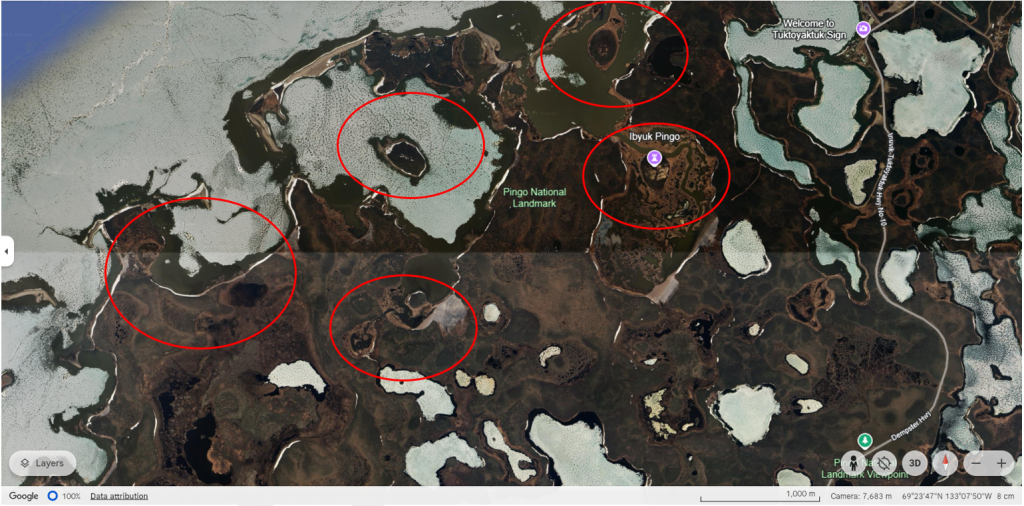
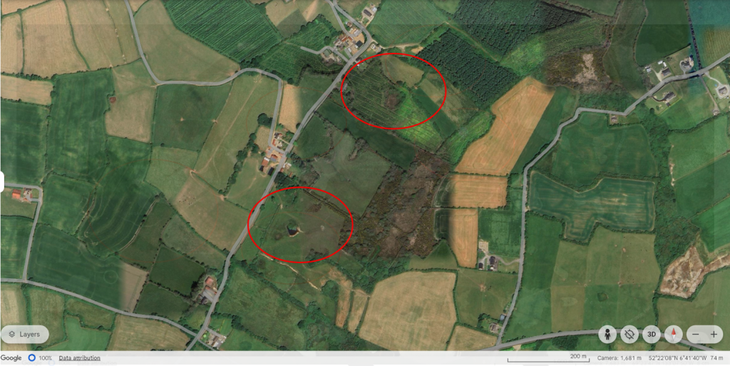
- Compare active pingos here to inactive ones e.g. Ireland. Some pingos circled in red below.
- Click here or open Google Earth and search for ‘Pingo National Landmark, Canada’ and ‘Camaross, Co Wexford, Ireland’. Differences/ similarities between the two?
- Geological Survey Ireland County Geological Site report here for further information on Irish ones.
- Photos from 1960s could also be used to identify pingos and compare to current aerial shots to see what’s changed.
Part 3: The outing / field trip
Option 1:
Coordinating a local outing with Jennifer Humphries from the Aurora Research Institute (ARI) or Alice Wilson from the NWT Geological Survey, based at ARI.
Jennifer and/or Alice will take the class out and lead one, or all, of the following activities based on time:
- Measure the active layer (top of permafrost)
- Measure the snow depth and ground temperature
- Compare and contrast ice wedge measurements in different locations and observing them
Ideally this will be done at a few locations to be able to build up a database to monitor change, as well as going several times in the year to track differences (if any) throughout the year.
- At each location, group work
- Observe and note surroundings – rock types, vegetation, land marks, animals, weather, sounds
- NOTE there are no wrong answers – it’s an observation and students should write what they see and any initial thoughts before going further to investigate and maybe go back to change some initial thoughts based on investigation
- Each group does tests in a different area:
- Analyse permafrost using NWT kit: https://sites.google.com/nwtresearch.com/nwtstemkits-ca/beaufort-delta/permafrost-probes?authuser=0
- water sampling analyses – use NWT kit: https://sites.google.com/nwtresearch.com/nwtstemkits-ca/beaufort-delta/copy-of-water-testing-kits?authuser=0
- quadrant bio count
- kick sampling opportunities in warmer weather and if near streams
- air quality
- sound quality
- light pollution
- Each group can do a different test at each location to then compile results together
- Repeat for each of the stops
- Observe and note surroundings – rock types, vegetation, land marks, animals, weather, sounds
- Input data here, by clicking on the link https://arcg.is/04uvmC or scanning the QR code

Option 2:
Using stops from “Beaufort Delta Region (22-27 June 2024 Canadian Permafrost Association field guide): Case Study of the Dempster Highway” field guide (found in Resources)
- If possible, go several times in the year to track differences
- Group work
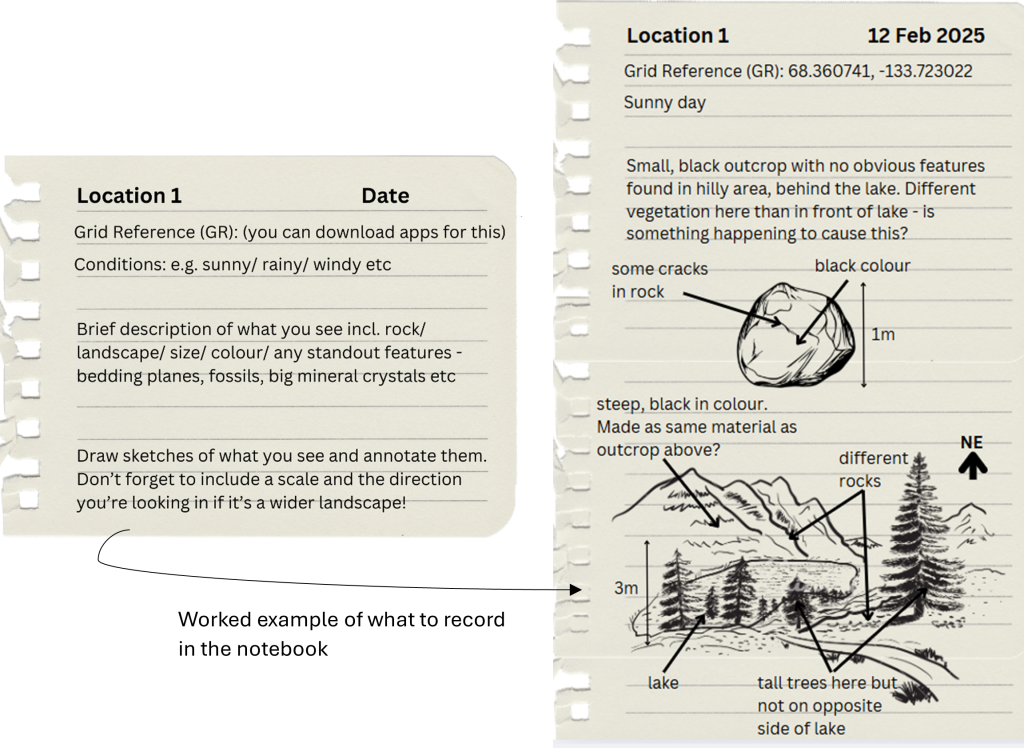
- Observe and note surroundings – include grid reference (lat. and long. coordinates), rock types, vegetation, land marks, animals, weather, sounds
- see pictures above of worked example
- Each group does tests in a different area:
- Analyse permafrost using NWT kit: https://sites.google.com/nwtresearch.com/nwtstemkits-ca/beaufort-delta/permafrost-probes?authuser=0
- water sampling analyses – use NWT kit: https://sites.google.com/nwtresearch.com/nwtstemkits-ca/beaufort-delta/copy-of-water-testing-kits?authuser=0
- quadrant bio count
- kick sampling opportunities in warmer weather and if near streams
- air quality
- sound quality
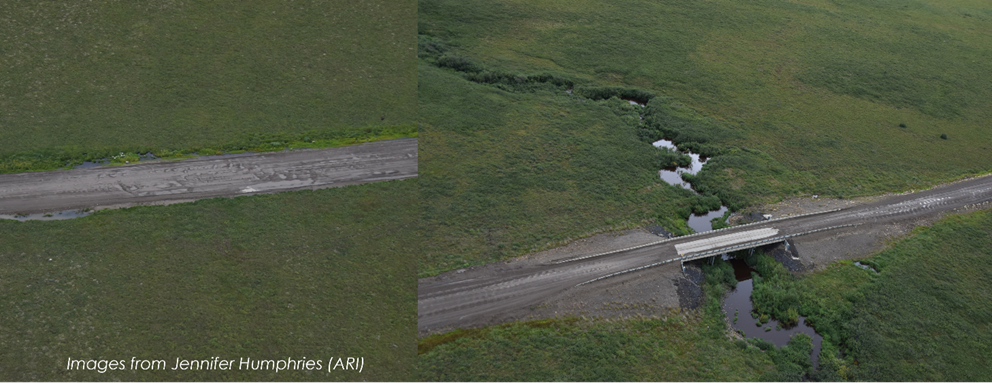
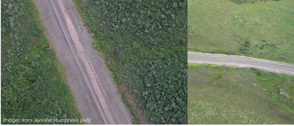
- Each group observes and analyses the road at a different section – what can you see? Are there any changes? Write this down to compare in class
- Repeat for each of the stops
- Observe and note surroundings – include grid reference (lat. and long. coordinates), rock types, vegetation, land marks, animals, weather, sounds
- Input data here, by clicking on the link https://arcg.is/04uvmC or scanning the QR code

- Share findings. Any patterns? Any reasons for any findings?
- What are the important parts to share? What’s normal?
- Compare to other years / times of years. How has it changed/ not changed
- If these changes are significant, how can we go about mitigating them? Can we use this to inform gov. decisions?
- Buddy system with grade 3s and higher grades – higher grades can collect more advanced data and synthesize findings for grade 3s
- Reflect on what it means to live in a permafrost area and any adaptations that have been made
- Activity: considering what you’ve learnt, use aerial photos and geological/ bedrock/ permafrost maps to determine where you would build a road (or other building), taking into account where it would be most stable and least at risk from hazards etc and where to get material from to build the road
- Recreate climate change trends with NWT ice core kit: https://sites.google.com/nwtresearch.com/nwtstemkits-ca/beaufort-delta/curious-about-climate-change?authuser=0. Discussion about this and what we can hypothesise based on findings from trip.
How can the Community Science Liaison program help?
- Explain and go through module with teacher
- Provide links for research / intro
- Help explain and expand geological background
- Create survey123 app to post findings – class can then use data for their discussions and use it to track the data