Permafrost StoryMap https://storymaps.arcgis.com/collections/f88936d53ca747eabd38a95ac53668bd?item=1
Grow your own pingo
https://epe.lac-bac.gc.ca/100/205/301/ic/cdc/simply_science/scirep1o.htm
Monitoring the depth and freezing in soil
https://ine.uaf.edu/werc/projects/permafrost/frost_tube.htm
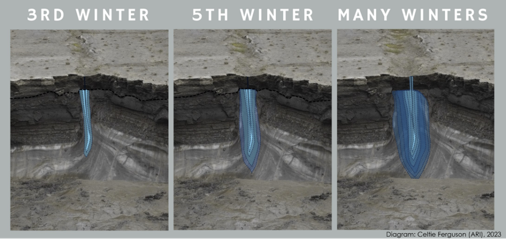
Diagram of ice wedge formation
Basics of permafrost
https://canadianpermafrostassociation.ca/Elements-of-Permafrost-Science.htm
Introduction on permafrost
https://www.youtube.com/watch?v=cMbIKJJvrwo
Frozen Ground cartoons
https://frozengroundcartooncom.wordpress.com/wp-content/uploads/2020/04/fgc_en_reimpression-lux_planches.pdf
Virtual tour of CRREL (Cold Regions Research and Engineering Laboratory) permafrost tunnel in Alaska
https://virtualice.byrd.osu.edu/permafrost/
Beaufort Delta Region (22-27 June 2024 Canadian Permafrost Association field guide): Case Study of the Dempster Highway
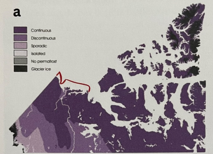
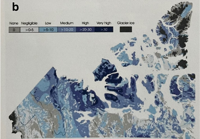
What is permafrost incl. Fig 1 and the climate of the region – J.K. Humphries
Climate Context
The Beaufort Delta Region has a subarctic climate south of the treeline (Taiga Plains) and an arctic climate north of the treeline (Southern Arctic) (Ecosystem Classification Group, 2007, 2012). Winters are long and cold with air temperatures remaining below 0°C from October to April. Spring is short-lived in April and May, as snow melts quickly due to the extended day lengths. It’s worth noting that temperatures near the coast, such as Tuktoyaktuk, are considerably cooler than those experienced inland in Inuvik, as energy is used to melt sea ice and warm the oceans. During the warmest summer months of June and July, air temperatures occasionally reach the high 20s (°C ) or even love 30s (°C).
Permafrost Basics
Permafrost is a temperature condition defined as ground that remains at 0°C for two or more years. Permafrost can consist of rock, sediment, organic materials and ice. In some environments, near-surface permafrost is comprised mainly of ice. The ice volume within permafrost is of interest because the development or loss of ground ice leads to heave or subsidence. When ice-rich terrain is distributed, the top of permafrost may thaw, causing the ground to sink (or subside). The more ice in the ground, the more it may subside. This sensitivity or permafrost terrain to disturbance is a significant challenge for development in the region [Beaufort Delta Region].
Ground surface temperatures are closely related to air temperature. However, linkages between air and ground temperatures can vary throughout the year due to vegetation, soil type, moisture and snow accumulation. These factors also cause permafrost temperatures to differ significantly between sites within a region. Within the first 1-2m beneath our feet, the ground freezes and thaws annually. This zone is called the ‘active layer’. Warm summer air temperatures thaw the active layer, while cool winter temperatures cause it to refreeze. As depth increases, it takes longer for variations in air temperature to reach a given depth, and a lag develops. The coldest air temperatures occur in January or February, but the coldest temperatures at depth in the ground (say 10m) occur months later in July and August.
Permafrost in the Beaufort Delta Region
There is thick (up to 700m) subsea permafrost off the coast of Tuktoyaktuk that extends 100km off the coast (marked red in figure above). Permafrost in the western Arctic is continuous, meaning it underliers more than 90% of the terrestrial environment (figure above). Permafrost is absent beneath lakes and river channels. These pockets of unfrozen ground are called taliks. The abundance of waterbodies and shifting nature of channels in the Mackenzie Delta contributes to thinner and patchier permafrost conditions. Permafrost is several hundreds of meters thick, and ground temperatures in undisturbed terrain range from -3 to -7°C on the tundra close to the Beaufort Sea Coast. There is a southward increase in ground temperatures and a decrease in thickness across the tundra-treeline transition. Ground temperatures around Inuvik area typically -1 to -3°C, and permafrost in less than 100m thick. In the Mackenzie Delta, permafrost is thinner and relatively warm. Flooding and alluvial succession cause high spatial variation in near-surface permafrost temperatures, ranging from -1 to -3°C in the central delta. Ice-rich permafrost characterises the Beaufort Delta Region.
Diverse geology, climate history, and geomorphic conditions have given rise to a wide range of ground ice types, including relict ice remnant from the last glaciation, networks of wedge-ice that have developed due to the cold Holocene climate, and segregated ice that has formed where the permafrost table has aggraded due to sedimentation or vegetation succession. The diversity of permafrost environments in the Beaufort Delta Region creates unique opportunities to observe a wide range of permafrost conditions, and varying responses to climate change and infrastructure development.
Potential stops for fieldtrip
| Dempster Highway (stops by km): | info pages 4-15 | |
| Km | Site | Topic |
| 270 | Inuvik town | Briefing |
| 221 | Gwich’in Territorial Park | Rest stop |
| 178 | Rengleng River | Streamflow regimes |
| 134-144 | Mackenzie River Crossing (Tsiigehtchic) | Ferry crossing, history, river conditions |
| 76 | Nitaiinlaii Territorial Park | Rest stop |
| 74 | Peel River Crossing | Ferry crossing |
| 52 | Peel Plateau Lookout | Glacial history |
| 44 | Midway | Gwich’in gathering place |
| 29 | ‘CB’ thaw slump | Glacial history and slump evolution |
| 28 | ‘D1’ road collapse | Maintenance challenges |
| 8.5 | Monitoring site | Thermal inversions and monitoring networks |
| 0/465 | Yukon – Northwest Territories Border | Winds and maintenance perspective |
| Inuvik – Tuktoyaktuk Highway ITH (stops by km): | info pages 17-33 | |
| km | Site | Topic |
| 0 | Inuvik Town | Briefing |
| 8 | Bridge 8 | Icing development and winter stream flow |
| 15 | Lantern Lake vista | Aggregate, treeline transition and glacial history |
| 40 | Thermoerosion and culverts | Thermal degradation and culvert performance |
| 42 | Trail Valley Creek | Snow manipulation |
| 69 | Polygonal terrain and thaw consolidation | Ice wedges, degradation & road thermal regime |
| 106 | Injection ice | Injection ice and frost blisters |
| 131 | Gunghi Creek | ITH construction |
| Pingo National Landmark | Rest stop and Parks Canada | |
| Tuktoyaktuk | Coastal erosion and community resilience | |
| Mackenzie Delta and Reindeer Station | info pages 40 – 47 | |
| Site | Topic | |
| Inuvik Town | Briefing | |
| Gill’s Camp | Evolution of permafrost temperatures in deltas | |
| Reindeer Station | Landslides and historic context | |
| Finger Hills | Landslides and IRC monitoring | |
| Blueberry Monitoring Site | Ground ice and alluvial succession of M Delta | |
History of Highway – S.V. Kokelj and J.K. Humphries
The Dempster Highway was completed in 1978 and opened in 1979 to provide the newly established town of Inuvik and the communities of Forst McPherson (Teetł’it Zheh) and Tsiigehtchic with an all-weather road for the movement of goods, private travel, tourism and sustainable land-use. It roughly follows the route taken by the North West Mounted Police between Dawson City and Fort McPherson in the early 1900s and was named after Corporal WJD Dempster of the Mounted Police, who led the expedition to find the Lost Patrol in 1910-1911 (Morrison, 1986).
The first iteration of the road was a seasonal tractor trail built over the winter of 1954 (Lignau, 1985). Construction of the all-season road began at the junction with the Klondike Highway in 1958, and the entire road took more than 20 years to complete. A passive design approach focused on preserving permafrost instead of stripping organic materials and thawing the terrain before construction.
Anticipating that the road embankment would settles, 2-3 years were given before road surfacing. A minimum embankment thickness of 1.4m protected the underlying permafrost from thawing. Regular maintenance and significant improvement projects have been necessary since completion. Some of the more recent projects include selected improvements as part of the NWT Highway Capacity Upgrade Project between 2015-2019 ($18 million), reconstruction and widening from km 0 to 259 as part of the Canada Strategic Infrastructure Fund from 2008-2014, and embankment widening and rehabilitation for km 245-255 in 2022.
Pingo National Park – C.R. Burn
The Pingo Canadian Landmark is a special designation of Parks Canada to identify one of the features unique to permafrost environments. The area of the landmark contains several closed-system pingos, including Ibyuk Pingo, the largest pingo in Canada. Ibyuk Pingo began to grow over 1200 years ago when its antecedent lake drained.
Pingos are ice-cored hills. The pingos of the western Arctic are closed-system, or hydrostatic, pingos. They form during permafrost aggradation after lake drainage into the unfrozen sediments of the lakebed. Once the former lake bottom is exposed to the atmosphere, permafrost growth into the talik begins. Expansion of water during freezing of the saturated sediments leads to excess volume in the ground.
Dr J.R. Mackay demonstrated that growing closed-system pingos are lifted on a water lens that represents the volume generated by freezing of the saturated sediments. In the 1970s, he punctured one of the pingos growing east of Tuktoyaktuk and observed a geyser of water released under the pressure of the water lens. The pingo subsided as the water was released. Later, after the drill hole had frozen, he obtained measurements of the pressure in the lens equivalent to the weight of the overburden.
Mackay also undertook long-term surveys of pingo growth at several sites in Tuktoyaktuk Coastlands. He demonstrated that pingo growth declines with time, because permafrost aggradation slows as the distance from the surface to the freezing plane increases. He surveyed Ibyuk Pingo over several years in the 1970s and determined its rate of growth to be about 2cm/ year. The surveys on Ibyuk were made by repeated levelling of benchmarks installed on the west side of the pingo. The instrument used was a WILD NA2 instrument with an optical micrometer. This enabled levels to be obtained with a precision of <0.1mm. these surveys were conducted 50 years ago. More recent surveys using GPS technology suggest that Ibyuk has now stopped growing. The longevity of Ibyuk’s growth means that its slopes are now steep and there is a large crater at the summit formed by dilation cracks that have widened as the pingo has grown.
About 1400 pingos were mapped by Mackay and J.K. Stager in the Tuktoyaktuk Coastlands from aerial photographs in the 1960s. Recently, analysis of the terrain surface using a digital elevation model has identified many others because low, circular mounds are more readily recognised digitally than by visual inspection.